The Scottish Ecological Design Association has been progressing at pace with the organisation of their 6 Land Conversations. The first one will be held later today, details and booking at A New Vision for Land Use in Scotland.
Land use in Scotland and its immediate products are varied and spatially complex. They are influenced by matters of ownership and political will and a range of external agents of both human and natural origin. A matrix and decision tree are being developed as an aid to understanding the complexity.
[The tools were developed and updated during the conversations – later versions and examples of their use are given at SEDA Land Conversat-ons
Matrix
A matrix of land use and outputs is is intended both to help set the scene and to summarise discussion over the coming weeks. The matrix as it stands at 1200 today 1 March 2021 is shown below (Fig. 1).
Land use is divided into broad categories of energy, water, urban/industrial, wild land, rough grazing, grassland, arable land, integrated/local enterprise and forest/woodland. The columns represent a second major dimension – things that the land provides or imposes as a result of management acting within local constraints. Categories include products from the land, economy/employment, pollution/losses, wildlife/shared space and human wellbeing.
Other dimensions are indicated outside the matrix. There are factors of land ownership and political will (columns to the right, left unfinished at this stage) and external influences (grey row below). The external influences can be further divided into those that are caused mainly by human interventions, such as the import-exports balance, wars and blockades; and those that can be classed as natural phenomena, such as weather and climate, storms and volcanic eruption. Pervading the whole, but not included in the matrix as shown in Fig. 1 is the biophysical baseline – geological and climatic history, topography, soils and our location on the Atlantic fringe.
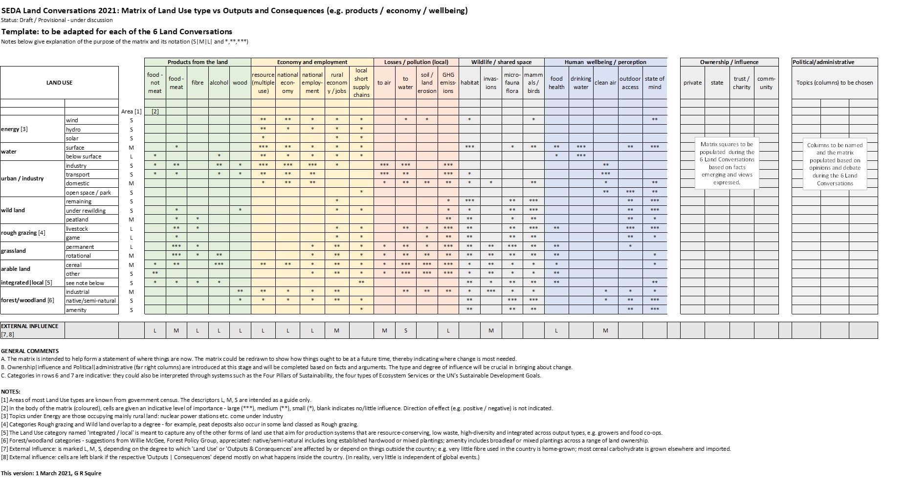
Fig. 1 Matrix of land use classes (listed left, in rows) and things provided by the land, which are not all positive (coloured blocks, columns). A further dimension of ownership and political will is indicated by the grey columns to the right and the complex and varied external influences are represented very simply by the grey row at the bottom. Click for a PDF to view detail, including notes.
Each cell in the matrix is given a simple provisional score from empty, indicating little relation between the land use type (rows) and the output (columns), and then *, ** or *** indicating increasing relation or effect.
At this stage, the categories in rows and columns and the scoring in the cells are provisional and for illustration only. They are expected to evolve during the course of the Land Conversations in the light of discussion, comments and new understanding. The development of the matrix will be charted here with acknowledgements to those who have contributed.
Decision tree: a semi-quantitative assessment tool
The matrix is also being converted to a decision tree in DEXi software [1]. Like the matrix it will evolve with the Land Conversations. An initial description showing land use categories as branches of a tree and the other dimensions listed to the right is shown in Fig. 2.
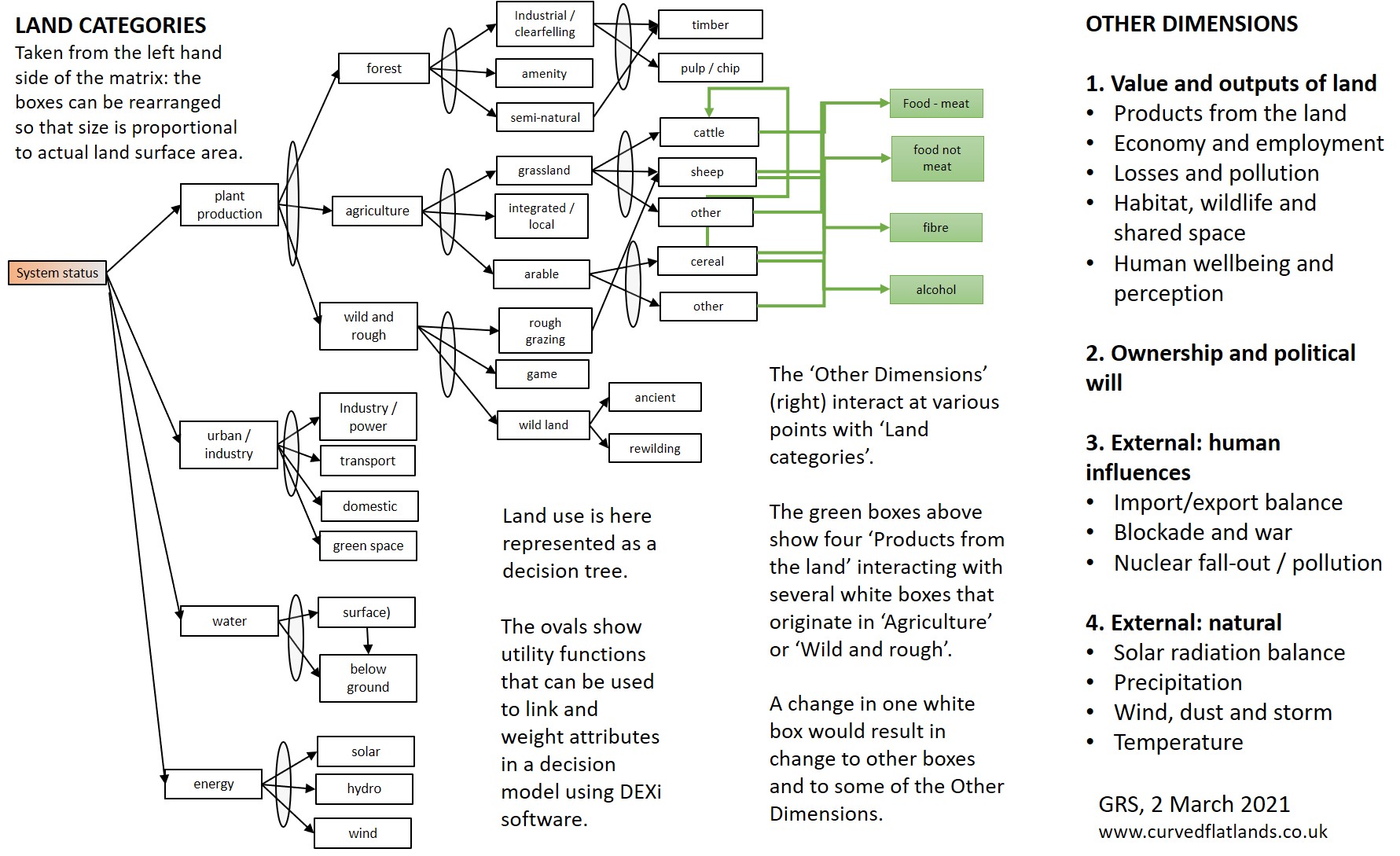
Fig. 2 Diagram to illustrate the use of decision tree software as a means of organising the multiple dimensions of land use. The tree to the left shows the land categories, slightly modified from Fig. 1. The other dimensions, including the columns from the matrix, ownership/political will, and the various human and natural external influences are listed to the right. Each of the Other Dimensions interacts with the land use tree at many points, and any one interaction will affect other aspects of land use and other dimensions. Click for a PDF of the above.
Acknowledgements | contributions
- SEDA and in particular Gail Halvorsen and David Seel for continued interaction over the scope and use of the matrix.
- Will McGee from Forest Policy Group for suggesting realistic categories for the forest/woodland land use types.
Sources | references
[1] Decision models in DEXi are widely used in ecology and system studies. DEXi from Marko Bohanec at the Josef Stefan Institute, Slovenia is available to download: DEXi: a programme for multi-attribute decision making
Contact: geoff.squire@hutton.ac.uk or geoff.squire@outlook.com
[Updates – 2 March with decision tree figure and 3 March with text edits.]