By GR Squire, N Quesada, GS Begg
An extended version of an article first published as a Hutton-LEAF Comment on 30 November 2018.
An update on progress with agroecological mapping to aid environmental risk assessment: a method for estimating pesticide treatment in Scotland’s arable-grass production systems.
The question
The combination of grassland for grazing animals and arable land for growing crops has sustained human life here since the first farmers occupied the land in the late stone age (Neolithic). This balance of managed grass and arable, unploughed and ploughed, gives the countryside a diversity that changes with the seasons and over the years as arable moves to grass and back.
Most of the suitable land lies within 40 km of the sea. The climate is ‘oceanic’, in that the large body of sea water dampens fluctuations in temperature, the land rarely suffers drought and the solar income during long summer days supports a high potential yield. The climate is ideal for grass and for temperate grain crops, such as barley and wheat, which typically yield more here than in any other part of the UK.
This proximity of farmland to sea, while beneficial to yield, also brings a potential risk to estuarine and marine ecosystems through loss and transfer of some of the agrochemicals that are applied to most farmland to support high production.
A question addressed by the Agroecology group at the James Hutton Institute was how to define and quantify the potential agrochemical loading on different parts of the region.
Combining EU’s IACSs with national pesticide survey
Significant progress has been made in the last year by combining three sources of data: the EU’s Integrated Administration and Control System or IACS [2] and government surveys of pesticide [3] and fertiliser [4].
The IACS data give the type of crop and grass grown on each field over a sequence of years. The information is submitted by farmers to regional or national governments and then the EU to register and claim under the EU’s Common Agriculture Policy. The pesticide and fertiliser surveys, presented both for Scotland and for England & Wales, are based on a sample of the total farms and record the number of applications and mass of substances applied to the main types of crop and grass.
Data from the pesticide survey for Scotland are used here to illustrate the method. The various forms of crops and grass differ greatly in their treatment with pesticide. For example, most managed grass, whether ‘permanent’ or ‘rotational’ gets no pesticide; and even the few fields treated, usually for broadleaf weeds, have only one application in any year. In comparison, spring cereals, the most prevalent crops in the region, have around 5 treatments (or pesticide formulations) in a year, mainly fungicide and herbicide, and the winter cereals 8-10 treatments while potato has the most, usually over 20 treatments.
Mapping pesticide load to crops and grass
Since each field has a spatial location and is defined by a sequence of crops and grass (both through IACS), each can be assigned an expected pesticide treatment based on the specific type of crop and grass in a defined year. Over a run of years, an average number of treatments per field can then be calculated to aid summary and visualisation.
Since the fields in any year differ very greatly in pesticide application (due to the specific crops grown) and crop systems tend to be clustered in some areas according to local microclimate and soil, the resulting maps show great variation both on a field-to-field scale and between sub-regions of the country.

A typical pesticide map is shown to the right (Fig. 2), this one for the east of the country between the Moray Firth and the Borders. It is based on an average of a five-year sequence of crops.
The areas coloured yellow had 0 to 2 pesticide treatments a year on average, but most of them, consisting of mainly grass, would have had none. The areas coloured the darkest brown had 9 or more treatments due to the combination in successive years of winter cereals, potato and vegetables.
The areas of densest pesticide loading are those known for their high yielding crops – Angus, Strathmore and the Carse of Gowrie, coastal Fife, East Lothian and the eastern Borders. The white areas outside the colouring tend to be upland rough grazing, of which less than 0.5% in the country as a whole is treated with pesticide.
The map of pesticide loading does not show actual values in all fields –a much greater sampling effort than is presently possible would be needed to achieve that. The colours indicate what we call ‘nominal’ values, which is this case means the values that would occur if all farmers treated crops according to the respective average obtained from the pesticide survey. In general, however, the values will be closely representative of what actually happens since there is little scope, given present weed and disease incidence, for major deviation in conventional agriculture from the survey means.
Interpretation of the pesticide loading data
The maps and underlying data can now be interpreted for various purposes. One of our main activities is environmental risk assessment, where we need to define a general hazard to the wider environment due to multiple pesticide or fertiliser treatments to land. If an assessment is for coastal waters, then the hazard relates to the damage to ecosystem processes that might occur if the agrochemicals ‘leaked’ from fields into water courses and then into the estuaries and sea. More specific hazards can be quantified through knowledge of the ecotoxicity of individual active substances or combinations of them.
Whether damage to environment occurs in practice depends on a term called ‘exposure’, which quantifies the likelihood that the target ecosystems come into contact with the hazard. In the case of pesticide and fertiliser, incorrect application of substances at the wrong time, ineffective cultivation that allows surface runoff of rainwater, poor maintenance of riverine vegetation and many other incorrect management practices will all increase exposure. The risk of damage to estuarine and marine systems will then depend on the combination of hazard and exposure across waterways and catchments.
The data can be used to explore a range of other ‘what if’ questions: for example, the action that would need to be taken to remove the severest pesticide hot spots, and the proximity in space of specific pesticides and vulnerable non-target organisms.
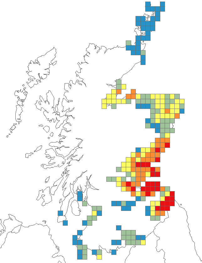
For example, the map above right (Fig. 3) shows the average per-field pesticide data aggregated into grid squares. The procedure in this instance was to examine where a certain high-input crop was grown, the other crops it was grown with and from that estimate the average pesticide use in 10 km squares as a means of rapid visualisation of potential hot-spots.
Future work on upscaling for risk assessment
With each field precisely located, it is feasible to analyse pesticide (and also fertiliser) input for any geographical shape, such as a river catchment, and ecological area or any form of grid.
In 2018/19, we are attempting to quantify the effects on pesticide input at farm, catchment and regional scales of replacing current crop varieties with ones having genetic resistance to pests or to agrochemicals and replacing chemical-only solutions with integrated pest management (IPM). The intention is to publish this work in the scientific literature.
Coupled with the geospatial analysis, The James Hutton Institute’s experimental farms are developing and testing a range of cultivation methods to reduce the environmental risk associated with growing crops and grass. They include effective management of field margins to limit surface losses, introducing mixed crops to reduce disease and hence pesticide input and increasing the areas grown with legumes that fix their own nitrogen so need no mineral N fertiliser.
The value of the mapping outlined here lies in our being able to upscale the effects of any innovation to estimate change at the extent of river catchments and agro-climatic regions.
Authors/roles: Geoff Squire – crops, climate, yield and inputs; Nora Quesada – IACS analysis, geospatial mapping; Graham Begg – geospatial mapping, systems, contact for the Agroecology group.
A contribution to Dundee and Angus Marine Week – Project Legend #ideasbecomelegend
The original article was first published on the worldwide web as follow: Squire GR, Quesada N, Begg GS. 2018. Mapping pesticide loading in Scotland’s maritime arable-grass. A Hutton-LEAF commentary, 30 November 2018: https://www.hutton.ac.uk/learning/leaf/comment. James Hutton Institute, Dundee DD2 5DA, UK. Contact: geoff.squire@hutton.ac.uk, nora.quesada.pizarro@hutton.ac.uk, graham.begg@hutton.ac.uk.
Sources
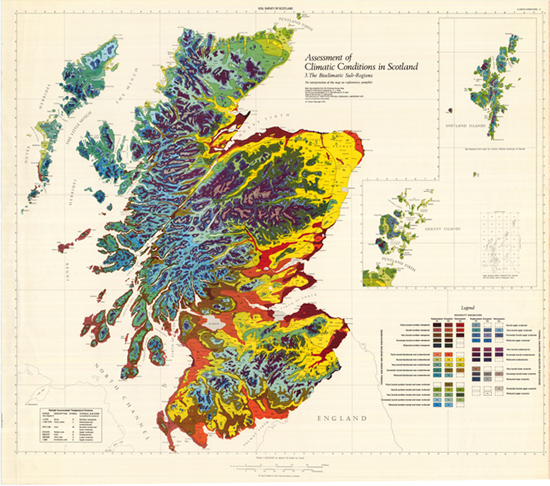
[1] Birse EL. 1971. Assessment of the climatic conditions of Scotland 3. The bioclimatic sub-regions. Soil Survey of Scotland: Macaulay Institute for Soil Research, Aberdeen (now the James Hutton Institute).
[2] Integrated Administration and Control System, IACS: https://ec.europa.eu/agriculture/direct-support/iacs_en.
[3] Pesticide Usage Survey Reports, SASA: http://www.sasa.gov.uk/pesticides/pesticide-usage/pesticide-usage-survey-reports. In the example of the method given above, the total pesticide applied to each type of crop and grass is cited in a highly simplified form. The SASA reports give a full explanation of the methodology and definitions of pesticide treatment.
[4] Fertiliser Practice: https://www.gov.uk/government/statistics/british-survey-of-fertiliser-practice-2017.